Карты для Garmin -
BlueChart Atlantic 9.0
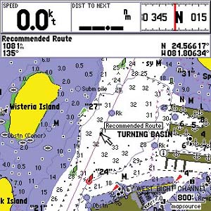
Водные карты Garmin BlueChart Atlantic. Состав картографической информации: отметки глубин, изобаты, береговая линия, фарватеры, надводные и подводные камни, острова, маяки, запрещенные зоны, места, где нельзя бросать якорь, заходы в порты и т.д.
Данная версия последняя, где присутствует немного территории России.
New Editions and notices to mariner changes
Coverage of additional Hydrographica (Sweden) lake charts including Lake Bolmen, Storsjon and Sommen
Includes Boatlaunch UK Slipways and S57 data for Latvia and Estonia
Coverage of Africa, Europe and the Middle East
Local charts for most countries using UKHO S57 data and high level Hydrographica, Sweden charts
Port services for the U.K., Ireland, Norway, Sweden, Denmark, Netherlands, France, Portugal, Spain, Italy and Croatia in cooperation with Bloc Marine, REEDS Nautical Almanac and other local vendors
Chart-specific information, including chart name, number, scale, revision date, latest Notice to Mariners date
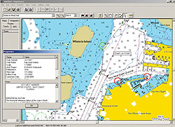
Trip and waypoint management function lets you transfer waypoints, routes and tracks between your GPS and your PC
Faithful representation of published official paper charts
Object-oriented cartography
Shaded depth contours
Intertidal zones
Spot soundings
Port plans
Navaids with view range and coverage
Tides, wrecks, restricted areas and anchorages
ПиС
Все прилагается в архиве.